
Paypay:USA Mass Cape Cod location map.svg

Size of this PNG preview of this SVG file: 560 × 420 nga mga pixel. Iba nga mga resolusyon: 320 × 240 nga mga pixel | 640 × 480 nga mga pixel | 1,024 × 768 nga mga pixel | 1,280 × 960 nga mga pixel | 2,560 × 1,920 nga mga pixel.
Orihinal nga paypay (SVG nga fayl, ginbabanabanahan nga 560 × 420 nga mga pixel, kadako han fayl: 264 nga KB)
Dalikyat nga pulong
| Tigtulidong |
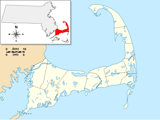
English: Location Map specific to (and zoomed to) Cape Cod, made specifically for the "WikiProject Massachusetts - Cape Cod and the Islands" on the English Wikipedia, but it is available to all.
For detailed instructions and several examples showing the various ways to use this file, see the documentation page at en:Module:Location map/data/USA Cape Cod. Specifications:
|
| Petsa | |
| Ginkuhaan | Kalugaringon nga buhat |
| Awtor | Grolltech |
| Other versions |
This file was derived from: USA Massachusetts location map.svg: |
| SVG genesis |
Palilisensya:
I, the copyright holder of this work, hereby publish it under the following license:
Ini nga file in nakalisensya ha ilarom han Creative Commons Attribution-Share Alike 3.0 Unported license.
- Talwas ka:
- para han pagpasaro – para han pagkopya, pagpakalat ngan pagpadangat han buhat
- para han pagremix – pag-adapt han buhat
- Ha ilarom an masunod nga mga kondisyon:
- attribution – Kinahanglanon mo tagan hin kaangayan nga credit, paghatag hin sumpay ngadto ha lisensya, ngan igbutang an imo ginbag-ohan nga binuhat. Puydi mo ini buhaton ha bisan ano nga resonable nga pamaagi, pero diri nimo pagawson nga an naghatag hin lisensya nag-eendorso ha imo o ha imo paggamit.
- share alike – Kun imo ginsagol-hin-otro, gin-iba, o gin-hingayad han buhat, ikaw in angay gud là magpakalat han imo gin-amot ha ilarom la han [http:creativecommons.org/share-your-work/licensing-considerations/compatible-licenses pareho o naangay nga lisensya] sugad han orihinal.
Kaagi han paypay
Pidlita an adlaw/oras para makit-an an fayl nga naggawas hito nga oras.
| Pitsa/Oras | Thumbnail | Mga dimensyon | Gumaramit | Komento | |
|---|---|---|---|---|---|
| waray pa kasasapawi | 11:25, 13 Mayo 2013 | | 560 × 420 (264 nga KB) | Grolltech | reshaped Monomoy; added overlay layers to facilitate reuse of this file |
| 22:45, 7 Mayo 2013 |  | 560 × 420 (189 nga KB) | Grolltech | further reduced thickness of town boundaries, land outlines | |
| 08:10, 6 Mayo 2013 |  | 560 × 420 (206 nga KB) | Grolltech | moved compass rose out of the way | |
| 17:39, 31 Mayo 2012 |  | 560 × 420 (205 nga KB) | Grolltech | 1) moved scale legend to the left edge, and 2) reduced thickness of town boundaries, land outlines, lakes and ponds. Both of these changes are intended lessen the impact on readability of pushpin labels. | |
| 17:21, 13 Mayo 2012 |  | 560 × 420 (206 nga KB) | Grolltech | added town boundaries | |
| 05:51, 13 Mayo 2012 |  | 560 × 420 (190 nga KB) | Grolltech | {{Information |Description ={{en|1=Locator Map for Cape Cod exclusively. Made for "Wikiproject Massachusetts - Cape Cod and the Islands". Equirectangular projection, N/S stretching 130.0 %. Geographic limits of the map: Northern boundary: 42.104... |
Mga Sumpay
An mga nasunod nga mga pakli nasumpay hini nga paypay:
Global file usage
An masunod nga iba nga mga wiki in nagamit hini nga file:
- Paggamit ha ar.wikipedia.org
- Paggamit ha azb.wikipedia.org
- Paggamit ha ceb.wikipedia.org
- Paggamit ha en.wikipedia.org
- Cape Cod
- Cape Cod Canal
- Provincetown Harbor
- Cape Cod Baseball League
- Kennedy Compound
- Eastham Windmill
- Sagamore Beach, Massachusetts
- Attaquin Beach
- Provincetown Historic District
- Race Point Light
- Center Methodist Church
- Provincetown Public Library (old)
- North Truro Air Force Station
- South Harwich, Massachusetts
- Hyannis Armory
- Louis Brandeis House
- Nauset Archeological District
- Ancient Burying Ground
- Chatham Windmill
- First Universalist Church (Provincetown, Massachusetts)
- Adams-Crocker-Fish House
- South Harwich Methodist Church
- Osterville Baptist Church
- Old Higgins Farm Windmill
- Universalist Society Meetinghouse
- Poor House and Methodist Cemetery
- Cove Burying Ground
- Bridge Road Cemetery
- Old Indian Meeting House
- Ahearn House and Summer House
- Josiah A. Ames House
- Atwood–Higgins Historic District
- Barnstable County Courthouse
- Avant House (Mashpee, Massachusetts)
- Capt. Rodney J. Baxter House
- George I. Briggs House
- Benjamin Baker Jr. House
- Capt. Seth Baker Jr. House
- Nathaniel Baker House
- Baxter Mill
- Lemuel B. Chase House
- Canary-Hartnett House
- Brewster Old King's Highway Historic District
Kitaa durudamo nga global usage hinin nga file.